Interactive Aerial Tours
Photography and video content by West 360 Digital
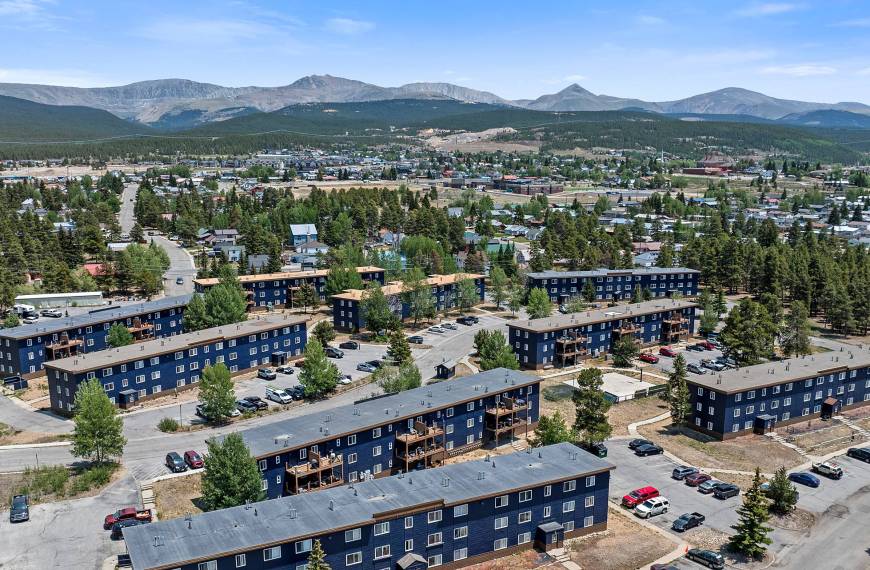
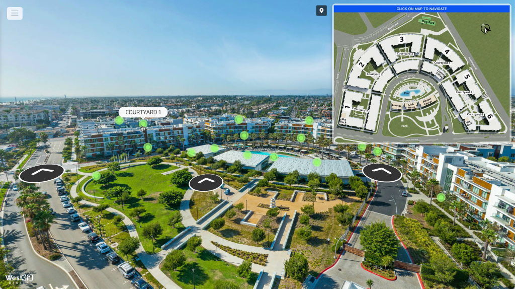
Drone Aerial Virtual Tour for The Residences at Pacific City apartment community in Huntington Beach, CA. Learn more about this project in our recent work post.
Why Interactive Aerial Virtual Tours?
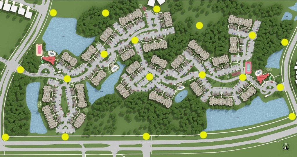
Map Feature
We strategically capture drone panoramas throughout the community to ensure a comprehensive view of the area. All panoramic shots are taken at exactly 150 feet to make sure the tour is level and consistent.
Ground-level Perspectives
Ground-level panoramas give users a realistic sense of what it feels like to walk the property. These views highlight pathways, landscaping, building scale, and amenity proximity, creating a more human-scale experience that complements the aerial tour.
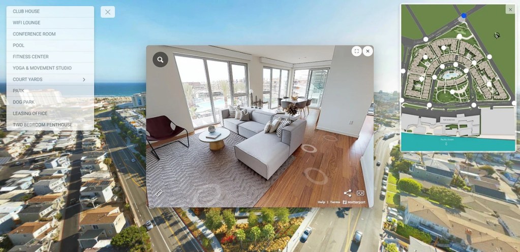
Dropdown Menu
This feature allows users to quickly navigate throughout the virtual tour without having to find specific amenities. We can add apartment units, amenities, and a Lease Now link to schedule a tour with a leasing agent.
Embedded Hotspots
We can embed Hotspot buttons throughout the community. This is perfect for future renters to see where each amenity is located on the property. We can add 3D Matterport tours, photos, 3D floor plans, and videos.


West 360 Digital Services:
Featured Drone Aerial Virtual Tours
Multi-Family apartment community Ashton Bellevue in Bellevue, WA.
Multi-Family apartment community Columbus Square in New York City for UDR.
Multi-Family apartment community Channel Mission Bay Apartments in San Francisco, CA.
Multi-Family apartment community 101 N. Meridian Apartments in Channel District Tampa, FL.
Multi-Family apartment community Brio Apartments in Bellevue, WA.
Multi-Family apartment community 399 Fremont Penthouses and Apartments in East Cut, San Francisco, CA.
Multi-Family apartment community Bradlee Danvers in Danvers, MA for UDR.
Frequently Asked Questions About Interactive Aerial Virtual Tours
What is an interactive aerial virtual tour?
We create interactive aerial virtual tours using drone panoramas so viewers can explore a property from above and better understand its overall layout, scale, and surrounding context. These tours are especially useful when you need to show more than a single building or entrance.
What types of properties are a good fit for aerial virtual tours?
We typically recommend aerial virtual tours for apartment communities, commercial real estate, mixed-use developments, campuses, hospitality properties, and other large sites where location, circulation, and amenity placement matter. They work especially well when the full story of the property is hard to capture from the ground alone.
How do aerial virtual tours help with property marketing?
Aerial virtual tours help prospects understand buildings, access points, amenity locations, and the broader setting before they visit in person. That makes them a strong marketing tool for leasing, sales, and general online presentation.
Can aerial virtual tours include ground-level views too?
Yes, we can combine aerial panoramas with ground-level panoramas to create a more complete experience. Ground-level views help people understand pathways, landscaping, building scale, and what it feels like to move through the property at eye level.
What interactive features can be added to an aerial virtual tour?
We can build in features like a map, dropdown navigation, and embedded hotspots to make the tour easier to use and more informative. Those hotspots can also link to apartment units, amenities, leasing calls to action, photos, videos, 3D floor plans, and Matterport tours.
Can aerial virtual tours be combined with other virtual tour services?
Yes, we can combine aerial tours with Matterport 3D virtual tours or Google virtual tours to create a more complete interactive package. This approach works well when you want both big-picture aerial context and immersive ground-level exploration.
How do you capture drone panoramas for aerial virtual tours?
We plan drone panorama capture to create a smooth, easy-to-follow aerial experience across the property. Our goal is to place each aerial viewpoint strategically so the final tour feels clear, consistent, and useful for understanding the site layout.
Does West 360 Digital provide aerial virtual tours nationwide?
Yes, we provide aerial virtual tour services across the United States with a process designed for consistent quality and professional execution. That makes this a strong option for both regional and multi-market property marketing needs.